Branch of the Santa Fe Trail |
Branch of the Santa Fe Trail |
 The Arkansas Valley offers a variety of water sports at various lakes.
Options include boating, sail boating, water skiing, and wind surfing. Warm
water fishing is available in the area's lakes and reservoirs. Trout is
stocked in Holbrook and Ordway reservoirs.
The Arkansas Valley offers a variety of water sports at various lakes.
Options include boating, sail boating, water skiing, and wind surfing. Warm
water fishing is available in the area's lakes and reservoirs. Trout is
stocked in Holbrook and Ordway reservoirs.
For thousands of years before Euro-American expeditions in the west, numerous Native American groups lived on the Great Plains. Many wintered in the Arkansas River valley, especially in the "Big Timbers", an area historically covered with large cottonwood trees, located downstream of the dam. With shelter, water and abundant food, the valley provided good camping.
Before the thirteen colonies were established, Spanish explorers venture into the Great Plains in the 1500s. After the Louisiana Purchase in 1803, the earliest documented American expedition through the valley was that of Lt. Zebulon Pike in 1806. In the immediate vicinity of the Project area, Pike first reported the sighting of the magnificent Rocky Mountains. The Lewis and Clark, Pike, Long, and Fremont expeditions gave rise to the creation of the U. S. Army Topographical Engineers. These schooled geographers were the first scientists to chronicle the West and were a precursor to the U.S. Army Corps of Engineers. The map below is a portion of the map documenting the route of Lt. Zebulon Pike's 1806 expedition through present day John Martin Reservoir. Note the spelling of the "Arkansaw" River! Notes on the map are barely readable and I was able to discern the following:
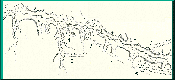 1. Here the Mountains are first seen.
2. Bottom- between this fork & main River.
3. Broken with small Ravines & Creeks.
4. Cotton Wood becomes frequent.
5. The whole of this Stretch is...both sides of the River by extensive...not
a stick of timber except a few clumps of Cotton Wood.
6. This Stretch of the River is Curved...
7. Innumerable Herds of Buffaloes. ...
 Early explorers, fur trappers, and the 1821 Mexican independence from
Spain led to the opening of the Santa Fe Trail trade. Bent's Old Fort was
the most renowned landmark on the Mountain Branch of the Santa Fe Trail.
Established about 1833 by Ceran St. Vrain and Charles and William Bent,
it served as a non-military post and center for the Mexican and Great Plains
trade. The Santa Fe Trail carried many immigrants west along the river valley
leaving a legacy and the wagon tracks still visible today. Reaching Santa
Fe in 1880, the railroad brought a halt to the wagon trade.
Early explorers, fur trappers, and the 1821 Mexican independence from
Spain led to the opening of the Santa Fe Trail trade. Bent's Old Fort was
the most renowned landmark on the Mountain Branch of the Santa Fe Trail.
Established about 1833 by Ceran St. Vrain and Charles and William Bent,
it served as a non-military post and center for the Mexican and Great Plains
trade. The Santa Fe Trail carried many immigrants west along the river valley
leaving a legacy and the wagon tracks still visible today. Reaching Santa
Fe in 1880, the railroad brought a halt to the wagon trade.
With the Plains Indians forced onto reservations, the frontier era came to a close. The region slowly filled with the families of ranchers and farmers. The valley continued to suffer occasional floods and the area survived the Dust Bowl of the 1930s. Drastic floods throughout the United States in the early 1900s raised concerns and the need for John Martin Reservoir was born.
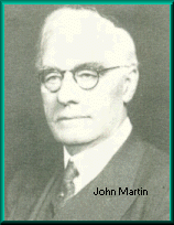 John A. Martin, Congressman was the greatest advocate of the Caddoa
Dam project. Primarily through his efforts, legislation for the project
was passed by Congress. Congress passed legislation that assigned the U.S.
Army Corps of Engineers with providing flood protection for the public's
safety. The 1939 Roosevelt approval meant the government would spend millions
on buying more than 20,000 acres of land and 21 miles of Santa Fe Railroad
tracks would have to be moved. Due to WWII, it wasn't until 1946 when the
project was back on track and finally completed in 1948. The length of the
dam is 2.6 miles with a height of 118 feet. Its discharge capacity is 639,200
feet with a drainage area of 18,913 square miles.
John A. Martin, Congressman was the greatest advocate of the Caddoa
Dam project. Primarily through his efforts, legislation for the project
was passed by Congress. Congress passed legislation that assigned the U.S.
Army Corps of Engineers with providing flood protection for the public's
safety. The 1939 Roosevelt approval meant the government would spend millions
on buying more than 20,000 acres of land and 21 miles of Santa Fe Railroad
tracks would have to be moved. Due to WWII, it wasn't until 1946 when the
project was back on track and finally completed in 1948. The length of the
dam is 2.6 miles with a height of 118 feet. Its discharge capacity is 639,200
feet with a drainage area of 18,913 square miles.
Representing the Third District of southeastern Colorado, John Martin faithfully served in Congress for two periods, and . Martin consistently fought for humane legislation and the welfare of his state. Martin was also instrumental in passing legislation for the Social Security Act. In June 1940, the Caddoa Project was renamed John Martin Dam and Reservoir in honor of the late Congressman.
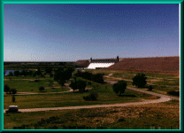
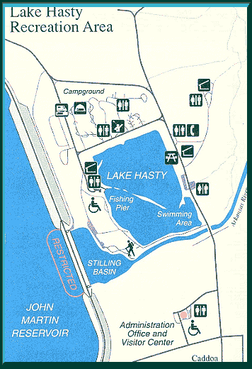
John Martin and Lake Hasty are located off Hwy 50 near Hasty. John Martin Reservoir is located on the Arkansas River, 1,159 miles upstream from its confluence with the Mississippi River. The project is located between Las Animas and Lamar, Colorado. The concrete and earthen dam serves to protect the Arkansas River Valley from potential flooding originating in the 18, 915 miles of the river's watershed. John Martin Reservoir is the largest body of water in southeast Colorado and a Santa Fe National Historic Trail Site. The reservoir is administered by the U.S. Army Corps of Engineers. The blue waters of the lake allow visitors a chance to enjoy a fun day of swimming, picnicking, camping, boating, water skiing, sailing, or windsurfing. Fishing is another popular activity both on the lake and nearby rivers. It provides boating, swimming, camping, fishing, hunting, hiking, picnicking and sight-seeing opportunities. An information center, information kiosks, a DAR marker and SFT wagon ruts can also be found at the reservoir.

 Fishing in John Martin Reservoir and Lake Hasty can be excellent for
walleye, saugeye, wiper, large and small mouth bass, crappie, channel catfish
and bream. Lake Hasty is also stocked with rainbow and cutthroat trout
each spring and fall.
Fishing in John Martin Reservoir and Lake Hasty can be excellent for
walleye, saugeye, wiper, large and small mouth bass, crappie, channel catfish
and bream. Lake Hasty is also stocked with rainbow and cutthroat trout
each spring and fall.
 Picnicking - Dine and relax outdoors. Picnic facilities are available
at the Overlook and Lake Hasty Recreation Area.
Picnicking - Dine and relax outdoors. Picnic facilities are available
at the Overlook and Lake Hasty Recreation Area.
Site Map |
La Junta Sites |
Lamar Sites |
Trinidad Sites |
Byway Museums |
Byway Events |
Byway Links |
