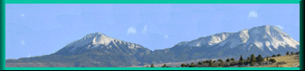
 The Spanish Peaks are west-northwest of Trinidad. They can be seen from
great distances along the Mountain branch, and they served as landmarks
for trail travelers. According to Indian legend, rain was created on these
Spanish Peaks in order to nurture the lands and produce a paradise on earth.
The Spanish Peaks are west-northwest of Trinidad. They can be seen from
great distances along the Mountain branch, and they served as landmarks
for trail travelers. According to Indian legend, rain was created on these
Spanish Peaks in order to nurture the lands and produce a paradise on earth.
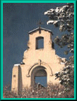 Located 10 miles south of Trinidad off Exit 6 on 1-25. Morley Church
is located at a former mining camp, in operation from 1907 until 1956. The
remains of the adobe walls of the St. Aloysius Church along with building
foundations from Morley, the once-thriving mining camp, still can be seen
today. The mountain slopes just north of the Raton Pass were bustling with
activity in the early 1900s. Even on the coldest of mornings, sounds of
miners were clearly heard echoing through the hills. Mule teams stood shuddering
on the outskirts, as men geared up for a long day in the mine. Morley Mine
was known for its clean, easily mined coal. Mule teams were hitched to long
rail cars and they hauled coal even from the deepest cavities. With the
prosperity of the community there became a need for a church and the community
raised enough money to build it nearby on a high peak. John D. Rockefeller,
owner of Colorado Fuel and Iron Company, was moved by the miner's efforts
and contributed to the project. Total funds raised were $2,300. The front
faced east and as the sun arose over the mountains, rays would glisten through
the belfry hollow. The men and women of the camp completed St. Aloysius
Church in 1917. Its old mission style architecture was constructed of cement
blocks covered in earthen stucco. Literally a labor of love, the miners
and their families took great pride in the church, dedicating it to St.
Aloysius. In 1950 the Morley mine began to phase out operations when costs
of coal removal made operations there no longer economically feasible. By
1956 St. Aloysius Church, most of the homes and businesses stood abandoned.
Although the camp is just a memory, the face of St. Aloysius has not missed
one day of standing and smiling to the rising sun.
Located 10 miles south of Trinidad off Exit 6 on 1-25. Morley Church
is located at a former mining camp, in operation from 1907 until 1956. The
remains of the adobe walls of the St. Aloysius Church along with building
foundations from Morley, the once-thriving mining camp, still can be seen
today. The mountain slopes just north of the Raton Pass were bustling with
activity in the early 1900s. Even on the coldest of mornings, sounds of
miners were clearly heard echoing through the hills. Mule teams stood shuddering
on the outskirts, as men geared up for a long day in the mine. Morley Mine
was known for its clean, easily mined coal. Mule teams were hitched to long
rail cars and they hauled coal even from the deepest cavities. With the
prosperity of the community there became a need for a church and the community
raised enough money to build it nearby on a high peak. John D. Rockefeller,
owner of Colorado Fuel and Iron Company, was moved by the miner's efforts
and contributed to the project. Total funds raised were $2,300. The front
faced east and as the sun arose over the mountains, rays would glisten through
the belfry hollow. The men and women of the camp completed St. Aloysius
Church in 1917. Its old mission style architecture was constructed of cement
blocks covered in earthen stucco. Literally a labor of love, the miners
and their families took great pride in the church, dedicating it to St.
Aloysius. In 1950 the Morley mine began to phase out operations when costs
of coal removal made operations there no longer economically feasible. By
1956 St. Aloysius Church, most of the homes and businesses stood abandoned.
Although the camp is just a memory, the face of St. Aloysius has not missed
one day of standing and smiling to the rising sun.
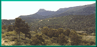
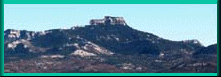 Fisher's Peak was a major landmark for travelers of the region, jutting
out from the surrounding mesa. It overlooks the entrance to Raton Pass between
Trinidad Colorado and Raton New Mexico. This distinctive mountain which
dominates the skyline of Trinidad is a basalt-capped mesa of volcanic origin.
Scientists date the formation of the mesa to a period of volcanic activity
more than one million years ago. During that time there were enormous crackling
fires, billowing columns of smoke and the sky darkened with layers of volcanic
ash. Rivers of molten rock flowed on the earth's surface, cooled over long
periods of time and formed new outcroppings. Additional volcanic activity
later produced more lava, which flowed across to add layers to the hardened
rock. Rising to an elevation of 9,626 feet, the peak dominates the skyline
south of Trinidad. A climax forest changes with altitudes. Up to about 7,000
feet, it is composed of cedars and pinon pines. Above that, tall, long-needled
ponderosa pines dominate up to about 9,000 feet where they are replaced
by Douglas fir and spruce. All of these climax forests are visible on the
slopes of Fisher's Peak.
Fisher's Peak was a major landmark for travelers of the region, jutting
out from the surrounding mesa. It overlooks the entrance to Raton Pass between
Trinidad Colorado and Raton New Mexico. This distinctive mountain which
dominates the skyline of Trinidad is a basalt-capped mesa of volcanic origin.
Scientists date the formation of the mesa to a period of volcanic activity
more than one million years ago. During that time there were enormous crackling
fires, billowing columns of smoke and the sky darkened with layers of volcanic
ash. Rivers of molten rock flowed on the earth's surface, cooled over long
periods of time and formed new outcroppings. Additional volcanic activity
later produced more lava, which flowed across to add layers to the hardened
rock. Rising to an elevation of 9,626 feet, the peak dominates the skyline
south of Trinidad. A climax forest changes with altitudes. Up to about 7,000
feet, it is composed of cedars and pinon pines. Above that, tall, long-needled
ponderosa pines dominate up to about 9,000 feet where they are replaced
by Douglas fir and spruce. All of these climax forests are visible on the
slopes of Fisher's Peak.
Fisher's Peak marked for travelers the beginning of Raton Pass, or the end, depending on their direction of North or South. There are a few interesting stories told about how the peak was named. The most popular legend tells of a Prussian Officer named Captain Waldemar Fischer, who traveled through southern Colorado on the way to Santa Fe, New Mexico some time around the year 1846. His party of soldiers got lost as they searched for the pass which would take them through the mountains into New Mexico. It was late in the day and Fischer decided to make camp and start off again the next morning. The day dawned bright and sunny. Spotting the prominent peak nearby, Fischer boasted that he could climb it and be back before his troops finished eating their breakfast. Several soldiers made a friendly wager with Fischer and it doesn't say whether or not he paid on the bet, when he undoubtedly lost. The hike up the Fisher's peak takes the better part of a day. He lost the bet, but won a bit of immortality. Proof of the community's fondness for its most recognizable landmark can be found in the countless times its image has been captured by local artists and used in the logos and names of local businesses. Today the peak and surrounding land is privately owned, and access is limited, but the view of this spectacular skyline south of town is free to everyone. Recently a tour operator with pack mules has opened it's doors and will take reservations for outings. They are working on their web site and when done, you can book tours at www.paladinranchretreat.com
 Korean War Memorial
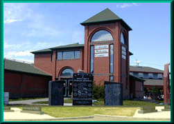
Located at the Colorado Welcome Center pictured at left. This memorial was dedicated to those men and women from Las Animas and Huerfano Counties who served our country in the Korean War. On the front are the names of those who served in Korea between 1950 and 1953, who were killed in action. On the back are additional names of veterans of this war. Information regarding inscriptions can be obtained at the Veterans Services office in the Las Animas County Courthouse. The Memorial is located at the Colorado Welcome Center.
Pictured above at the Colorado Welcome Center. This memorial displays the names of men and women from Las Animas County who served our country during WWII from December 7, 1941 through December 31, 1946. For information regarding inscriptions, contact the Veterans Service office in the Las Animas County Courthouse.. Inscriptions on the memorial are available at a cost of $80.00 each. Dedicated July 4, 2001.
Pictured above, this memorial was dedicated in the memory of the soldiers of Las Animas County who lost their lives in this war from 1965 — 1973. The reverse side recognizes more than 260 veterans from the Las Animas County area who were never honorably recognized when they returned. Dedicated on May 30, 1999, with more than 1200 veterans in attendance. For information, contact Bernie Gonzales at .
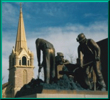
Be sure and visit The Coal Miner's Memorial in downtown Trinidad. It is the hub of many of the activities and festivals planned in the Historic District. The Memorial was a community project that was undertaken by the Trinidad-Las Animas County Hispanic Chamber of Commerce Coal Miners Memorial Committee. The project was erected by the Southern Colorado Coal Miners Memorial and Scholarship Committee and dedicated on May 24, 1997. Located in historic downtown Trinidad on West Main Street, the life-size memorial, cast in bronze by local artist Ben Johnson, stands in recognition of the contribution of hundreds of coal miners. The active, past, retired and deceased member's names of the coal mining industry are inscribed on the base of the monument. Replicas of the memorial and inscriptions in the black granite base of the monument help provide monetary support of education through scholarships, as well as maintenance of the memorial. Names of coal miners from 18 states are represented. Inscriptions can be purchased for $100 and replicas are available for $1000 by contacting the Trinidad-Las Animas County Hispanic Chamber of Commerce at . Correspondence can be mailed to: 1804 N. Linden Ave., Trinidad, CO, 81082.
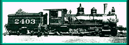
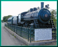 Located north of City Hall on Animas Street in Trinidad sits the last
coal driven steam engine in service for the C & S Railroad. Manufactured
in 1906 for the Colorado and Southern Railroad for service in Trinidad,
the engine remained in use until its retirement in 1963. Restoration on
the train was completed in 2001.
Located north of City Hall on Animas Street in Trinidad sits the last
coal driven steam engine in service for the C & S Railroad. Manufactured
in 1906 for the Colorado and Southern Railroad for service in Trinidad,
the engine remained in use until its retirement in 1963. Restoration on
the train was completed in 2001.
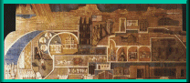 Located in the lobby of Mt. San Rafael Hospital in Trinidad. A three-dimensional
mural by Sister Augusta Zimmer, S.C., depicts the history of the area from
the Conquistadors search for the cities of gold to the present. Highlights
include Fisher's Peak, Simpson's Rest & Ludlow Monument.
Located in the lobby of Mt. San Rafael Hospital in Trinidad. A three-dimensional
mural by Sister Augusta Zimmer, S.C., depicts the history of the area from
the Conquistadors search for the cities of gold to the present. Highlights
include Fisher's Peak, Simpson's Rest & Ludlow Monument.
 Phone the Chapel for bookings.
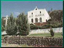
Located on the hillside south of Mt. San Rafael Hospital in Trinidad, the Ave Maria Shrine is one of the most beautiful and mysterious landmarks in Trinidad. Construction began in 1934 on the site where an early Trinidad physician who was caught in a vicious storm in 1908 and was led by a flickering light to a statue of the Virgin Mary, which had mysteriously appeared on the hillside. Many residents saw this as a divine sight. The Ave Maria Shrine is now a sanctuary of peace for all. Bus tours, pilgrimages and individual group tours are welcome.
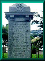
Located in the Kit Carson Park, Trinidad. This Marker is inscribed on all four sides with historical facts on the west and east sides. The DAR insignia and the Colorado state seal are on the other two sides. Note date of 1879 which indicates that the Trail was not used extensively after the coming of the Santa Fe Railway to southern Colorado in 1878. The Marker dedication was March 2, 1910. It is the largest DAR Marker on the Santa Fe Trial.
To learn more of our DAR markers in Colorado there is an excellent book of them by Mary B. and Leo E. Gamble. "Santa Fe Trail Markers in Colorado" available through your local Daughters of the American Revolution Chapter.
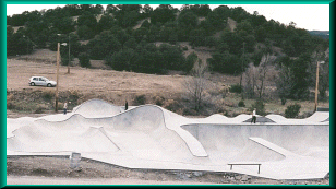
Trinidad Skate boarding Park- The newest addition to the Santa Fe Trail Mountain Branch Recreation facilities is a four star skate boarding park. One of Grindlines new masterpieces. The park flows really well and has some awesome and interesting elements, including a small overt pocket. An xtremely good skate park! The locals are cool and the scenery is great so add this to your list of new parks you must hit on the next road trip. Located just off the Santa Fe Trail near the Trinidad Community Center.
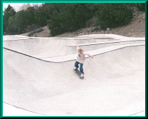 Take I-25 to Trinidad (14 mi. north of New Mexico)
Use exit 14A (Main St.)
Turn right at Santa Fe Trial (Sonic)
Turn left at Jefferson (Community Center Sign)
Turn right at the bottom of the hill (Community Center Sign)
Stay left approx. 500 ft.
RIDE TILL IT HURTS!!!
The park has been recently completed. 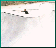
 Scenic Highway of Legends is our sister Colorado Scenic Byway. The route
winds along Highway 12 in a circular loop beginning in Trinidad near 1-25
and ending in Walsenburg where it connects back to 1-25. Along the way some
of Southern Colorado's most beautiful landscapes, numerous recreational
spots, historical structures and geological formations can be seen. Points
of interest include: Trinidad Lake State Park, Cokedale, Stonewall, Monument
Lake, North Lake, Cuchara Pass, Cuchara and La Veta. A stop at the Colorado
Welcome Center before leaving Trinidad will provide maps and brochures about
the various sites along the route.Take this Byway to discover fascinating
glimpses of the past in the Byways communities of La Veta, and Cuchara.
It is here where you will see the old remains of coke ovens in Cokedale.
Watch for Byway signs to guide you. Length: 82 miles, Driving time: 2 hours,
Contact: Trinidad Welcome Center, 309 Nevada Avenue, Trinidad CO 81082,, Website:
Scenic Highway of Legends is our sister Colorado Scenic Byway. The route
winds along Highway 12 in a circular loop beginning in Trinidad near 1-25
and ending in Walsenburg where it connects back to 1-25. Along the way some
of Southern Colorado's most beautiful landscapes, numerous recreational
spots, historical structures and geological formations can be seen. Points
of interest include: Trinidad Lake State Park, Cokedale, Stonewall, Monument
Lake, North Lake, Cuchara Pass, Cuchara and La Veta. A stop at the Colorado
Welcome Center before leaving Trinidad will provide maps and brochures about
the various sites along the route.Take this Byway to discover fascinating
glimpses of the past in the Byways communities of La Veta, and Cuchara.
It is here where you will see the old remains of coke ovens in Cokedale.
Watch for Byway signs to guide you. Length: 82 miles, Driving time: 2 hours,
Contact: Trinidad Welcome Center, 309 Nevada Avenue, Trinidad CO 81082,, Website:
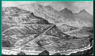
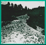
Our scenic and breathtaking Raton Pass is pictured here with a view of Fishers Peak. Interstate 25 takes you up and over the Pass where you will experience beautiful vistas across the entire pass. Get a close up look at Fisher's Peak before you reach the top of the pass. Here you will catch one last spectacular view of the Spanish Peaks as they turn into the Sangre de Cristo Mountain Range which marks the gateway to New Mexico. The Highway has been carved through the mountain top and shows the remarkable geologic changes in the earth through the years and stands nearly a mile and a half high. There are interpretive signs for your information along the pass, so be sure to stop at one of the pull offs for photo opportunities and to learn about the regions history.
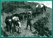
 Those who traveled the Mountain Route of the Santa Fe Trail viewed Raton
Pass as a grueling trek across the pass. In winter 1847, heading south from
Bent's Fort on the Santa Fe Trail, Lewis Garrard wrote, "We obtained
a view of the (shining) snow-piled Raton, at whose base our road runs."
Early traveler James Ross Larkin state in his "Santa Fe Trail Diary"
: Monday, November 3rd, "Some of the hills are awful for
wagons. . . very steep, . . . almost nothing but rocks. The Raton may be
called the dread of all mountain travelers. . . We reached the bottom of
the last hill in safety, and felt much rejoiced." Early Mexican
traders and herders chose the name Raton. Raton (rat, in English) refers
to wood rats that live on the Mesa's rocky mountain slopes. The steep slopes,
heavy timber and the lack of a defined road obstructed the progress of wagons
and coaches over Raton Pass. The wagons generally formed a single line while
ascending Raton Pass, and over time a deep cut was made at the crest. With
speeds as slow as 1/2 mile per hour, this stretch could take a week or more
to cross. For the modern traveler the pull up the mountain can be measured
in minutes.
Those who traveled the Mountain Route of the Santa Fe Trail viewed Raton
Pass as a grueling trek across the pass. In winter 1847, heading south from
Bent's Fort on the Santa Fe Trail, Lewis Garrard wrote, "We obtained
a view of the (shining) snow-piled Raton, at whose base our road runs."
Early traveler James Ross Larkin state in his "Santa Fe Trail Diary"
: Monday, November 3rd, "Some of the hills are awful for
wagons. . . very steep, . . . almost nothing but rocks. The Raton may be
called the dread of all mountain travelers. . . We reached the bottom of
the last hill in safety, and felt much rejoiced." Early Mexican
traders and herders chose the name Raton. Raton (rat, in English) refers
to wood rats that live on the Mesa's rocky mountain slopes. The steep slopes,
heavy timber and the lack of a defined road obstructed the progress of wagons
and coaches over Raton Pass. The wagons generally formed a single line while
ascending Raton Pass, and over time a deep cut was made at the crest. With
speeds as slow as 1/2 mile per hour, this stretch could take a week or more
to cross. For the modern traveler the pull up the mountain can be measured
in minutes.
From the book: "SANTA FE, The Railroad that Built an Empire"
 On February 26, 1878, two crews of railroad construction engineers arrived
in the boom town of El Morro, the Denver Rio Grande Railroads's rail head
and the Santa Fe crew. The D&RG crew headed to their hotel to sleep.
The other crew, from the Atchison, Topeka and Santa Fe, hurried to Raton
Pass to work. By the next morning, the race was over! The Atchison, Topeka
& Santa Fe had won. They purchased the right-of-way to the toll road
over Raton Pass from Wootton. Before dawn, the busy crew even scratched
out a little "roadbed" in proof of their claim. The crew received
help from Trinidad citizens, angry with D&RG for building the rival
town of El Moro, robbing them of much needed commerce. Hence the phrase
you snooze, you loose pertained!
On February 26, 1878, two crews of railroad construction engineers arrived
in the boom town of El Morro, the Denver Rio Grande Railroads's rail head
and the Santa Fe crew. The D&RG crew headed to their hotel to sleep.
The other crew, from the Atchison, Topeka and Santa Fe, hurried to Raton
Pass to work. By the next morning, the race was over! The Atchison, Topeka
& Santa Fe had won. They purchased the right-of-way to the toll road
over Raton Pass from Wootton. Before dawn, the busy crew even scratched
out a little "roadbed" in proof of their claim. The crew received
help from Trinidad citizens, angry with D&RG for building the rival
town of El Moro, robbing them of much needed commerce. Hence the phrase
you snooze, you loose pertained!
Richens Lacy Wooton was the son of a Mecklenbury County Virginia, planter. He was born May 6, 1816, and at twenty, struck out alone for Independence, Missouri, and joined a wagon train. He never went east again. He became a trader, Indian fighter, scout for Fremont, friend of Kit Carson, rancher, sheepman and toll-road owner. Indian fighting, although he did some, he considered nonsense. "Leave the tribes alone and they'll kill each other off faster than the soldiers can do it," he used to say.
 After some ranching and trading around in Denver and Pueblo, both of
which he helped to found, he thought he had better get himself some social
security for his old age. In 1864, "Uncle Dick" Wooton improved
the rugged route of the Santa Fe Trail over Raton Pass and opened a toll
road. He obtained franchises from the territorial legislatures of Colorado
and New Mexico, and hacked, blasted, cut and filled about twenty-seven miles
of highway from Trinidad on the north, to Red River on the south. He put
up a home and hotel on the north slope, slung a chain across the road and
did a thriving business. Some folks used the Cimarron cutoff instead, enabling
them to miss the mountains and the toll road all together. Barlow &
Sanderson stages used the route and so did sheep and cattle herders, miners
and traders. Everything on feet paid toll except Indians, posses after horse
thieves and occasional Mexicans. The Utes never had paid to cross their
own mountains and didn't propose to start. The posse men, usually with rifle
and rope in hand, stopped for nothing. Once in a while Uncle Dick menaced
Mexicans with an old army carbine and collected, and occasionally the Indians
would leave a blanket or deer skin. The hotel was a favorite stopping place
for the freighting teams and an open house for youngsters from Trinidad
and El Moro, who held dances there every week.
After some ranching and trading around in Denver and Pueblo, both of
which he helped to found, he thought he had better get himself some social
security for his old age. In 1864, "Uncle Dick" Wooton improved
the rugged route of the Santa Fe Trail over Raton Pass and opened a toll
road. He obtained franchises from the territorial legislatures of Colorado
and New Mexico, and hacked, blasted, cut and filled about twenty-seven miles
of highway from Trinidad on the north, to Red River on the south. He put
up a home and hotel on the north slope, slung a chain across the road and
did a thriving business. Some folks used the Cimarron cutoff instead, enabling
them to miss the mountains and the toll road all together. Barlow &
Sanderson stages used the route and so did sheep and cattle herders, miners
and traders. Everything on feet paid toll except Indians, posses after horse
thieves and occasional Mexicans. The Utes never had paid to cross their
own mountains and didn't propose to start. The posse men, usually with rifle
and rope in hand, stopped for nothing. Once in a while Uncle Dick menaced
Mexicans with an old army carbine and collected, and occasionally the Indians
would leave a blanket or deer skin. The hotel was a favorite stopping place
for the freighting teams and an open house for youngsters from Trinidad
and El Moro, who held dances there every week.
At one such dance came Strong and Robinson, a representative of the railroad. "Well," he said, "I guess I'll have to get out of the way of the locomotive." "The Santa Fe will do right by you," assured Robinson. After the line was Strong and Robinson met Dick's son, Dick Jr., in Trinidad. Strong asked the youngster if he thought $50,000 in cash would be about right for his father's road. "Let's go up and ask him," replied the boy. At the toll house the old man shook his head. "NO," he said, "I don't want that much money in a lump. I'll tell you--you give me and my family a lifetime pass and $25 a month in groceries, and we'll call it square." They shook on it. The agreement was kept until 1916, with Uncle Dick's widow getting the pass and the cash after his death in 1893. In 1925 the Santa Fe doubled the payment; in 1930 it increased it again to $75. After Mrs. Wooton's death, an invalid daughter, Miss Fidelis, got $25 a month during her lifetime. Dick died at seventy-seven, having fathered five sons and five daughters.
 So the Santa Fe Railroad dickered with Wootton for his road and in,
1878, the Santa Fe Railroad laid rails over the Pass. Trinidad hummed with
freight and passenger activity. To conquer the steep six percent grade,
were very tight switch backs, and the New Mexico & Southern Pacific
Railroad ordered a gargantuan locomotive from the Baldwin Locomotive Works
of Eddystone, Pennsylvania. Engine No. 204, named the Uncle Dick, was so
heavy that it had to be shipped in pieces for assembly in Trinidad. It was
the world's largest of its time, weighing 150,000 pounds. Twice as powerful
as other engines, yet burning less coal, it could pull 258 tons up the 3.5
percent main. The Uncle Dick easily negotiated the six percent grad and
tight curves of the switch backs over the summit. The Raton Pass tunnel
opened on September 1, 1879 and the temporary switch back line over the
summit was abandoned. The Uncle Dick was converted to a regular engine and
worked as a helper on the Pass until the advent of larger, more powerful
engines. In 1880 "Uncle Dick" often hauled the passenger train
from Trinidad to Las Vegas and handled the De Luxe Express from La Junta
to Santa Fe--298 miles. This De Luxe Express had three cars: a combination
coach with one end for ladies and the other for smokers. The De Luxe also
had a baggage-express-mail car; and a nifty little number of a car that
the Santa Fe had bought from the Intercolonial Railway of Canada. This car
was lined with hardwood panels and furnished with huge chairs upholstered
in red plush velvet from which tourists might view the wonders of the Rockies.
The chairs were on casters, and up in Canada they had worked fine, but around
the mountains, with ten-degree curves, they had skidded all over the car.
After one trip the casters were taken off and a few weeks later a sleeping
car was added.
So the Santa Fe Railroad dickered with Wootton for his road and in,
1878, the Santa Fe Railroad laid rails over the Pass. Trinidad hummed with
freight and passenger activity. To conquer the steep six percent grade,
were very tight switch backs, and the New Mexico & Southern Pacific
Railroad ordered a gargantuan locomotive from the Baldwin Locomotive Works
of Eddystone, Pennsylvania. Engine No. 204, named the Uncle Dick, was so
heavy that it had to be shipped in pieces for assembly in Trinidad. It was
the world's largest of its time, weighing 150,000 pounds. Twice as powerful
as other engines, yet burning less coal, it could pull 258 tons up the 3.5
percent main. The Uncle Dick easily negotiated the six percent grad and
tight curves of the switch backs over the summit. The Raton Pass tunnel
opened on September 1, 1879 and the temporary switch back line over the
summit was abandoned. The Uncle Dick was converted to a regular engine and
worked as a helper on the Pass until the advent of larger, more powerful
engines. In 1880 "Uncle Dick" often hauled the passenger train
from Trinidad to Las Vegas and handled the De Luxe Express from La Junta
to Santa Fe--298 miles. This De Luxe Express had three cars: a combination
coach with one end for ladies and the other for smokers. The De Luxe also
had a baggage-express-mail car; and a nifty little number of a car that
the Santa Fe had bought from the Intercolonial Railway of Canada. This car
was lined with hardwood panels and furnished with huge chairs upholstered
in red plush velvet from which tourists might view the wonders of the Rockies.
The chairs were on casters, and up in Canada they had worked fine, but around
the mountains, with ten-degree curves, they had skidded all over the car.
After one trip the casters were taken off and a few weeks later a sleeping
car was added.

Site Map |
La Junta Sites |
Lamar Sites |
Trinidad Sites |
Byway Museums |
Byway Events |
Byway Links |
