 Old Fort Lyon is less than 1 mile west of Bent's New Fort. Originally
called Fort Wise, this fort was built by the Army in 1860. A treaty with
the Cheyenne and Arapaho Indians was signed here in 1861, but it was not
honored by either side. Fort Lyon was deeply involved in the Indian troubles
of this region during and after the Civil War. This fort was relocated in
1867, and today only a few foundations of the officers quarters remain.
Santa Fe Trail wagon ruts are still visible north of this site.
Old Fort Lyon is less than 1 mile west of Bent's New Fort. Originally
called Fort Wise, this fort was built by the Army in 1860. A treaty with
the Cheyenne and Arapaho Indians was signed here in 1861, but it was not
honored by either side. Fort Lyon was deeply involved in the Indian troubles
of this region during and after the Civil War. This fort was relocated in
1867, and today only a few foundations of the officers quarters remain.
Santa Fe Trail wagon ruts are still visible north of this site.
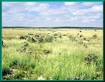
Bent's New Fort is 1 mile west of the Prowers-Bent county line on US 50, then 1 mile south on Prowers County Road 35, 0.2 mile east, and 0.5 mile south. This fort was operated by William Bent from 1853 to 1860, when he leased the site to the U.S. Army. Only foundation ruins outline the post.
7515 US Hwy 50, Lamar, CO , 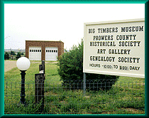 Hours: 1:30PM
- 4:30PM, 7 Days a Week
Hours: 1:30PM
- 4:30PM, 7 Days a Week
In the 1860s, there was a trading post at this location. The site gets its
name from the giant cottonwood trees which lined both banks of the Arkansas
River in this area. There was a log stockade at Big Timbers. Granada, Prowers
County is located in the Big Timbers area and at one time Big Timbers encompassed
land of about 40 miles east to west along the Arkansas River.
The Big Timbers Museum displays Indian relics such as arrowheads, war clubs, beads, stone tools, bows and arrows. There are also cowboy saddles, clothing, gear and pioneer fashions, furniture and firearms at the museum.The museum has many displays of early life in the area, genealogical records, memorabilia from the Revolutionary War to the Gulf War, many posters from various wars, etc. Well worth the visit.
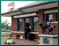 109 B, E. Beech, Lamar, CO , The Colorado Welcome Center
at Lamar is located in the heart of downtown Lamar in the Historic Lamar
Railroad Depot. This restored 1906 depot is still in use with daily Amtrak
service between Chicago and Los Angeles. Three major highways (U.S. 50,
U.S. 287, and U.S. 385) pass through town. Lamar is a progressive community
of 10,000 friendly folks, and is the retail, agricultural and manufacturing
hub of southeast Colorado. Please stop by for a cup of coffee and visit
with the volunteers who make our Welcome Center such a pleasant place. They
will help you with your travel plans, advise of road and weather conditions,
and ask you about your grandchildren.
109 B, E. Beech, Lamar, CO , The Colorado Welcome Center
at Lamar is located in the heart of downtown Lamar in the Historic Lamar
Railroad Depot. This restored 1906 depot is still in use with daily Amtrak
service between Chicago and Los Angeles. Three major highways (U.S. 50,
U.S. 287, and U.S. 385) pass through town. Lamar is a progressive community
of 10,000 friendly folks, and is the retail, agricultural and manufacturing
hub of southeast Colorado. Please stop by for a cup of coffee and visit
with the volunteers who make our Welcome Center such a pleasant place. They
will help you with your travel plans, advise of road and weather conditions,
and ask you about your grandchildren.
From Trinidad, head east on U.S. 160. The Old Granada site is about 3 miles east of the town of Granada, south of the Arkansas River and on the route of the Santa Fe Railway. Granada Fort Union Military Route was the end-of-the-track on the railroad from 1873 to 1875. The railroad carried most of the freight of the Santa Fe Trail to this point, where it was loaded onto wagons for the trip through Emory Gap to New Mexico. After the railroad was extended farther west, the site was abandoned, and the new town of Granada was laid out a few miles to the west. Ruts marked by limestone posts are visible along this southerly route. Where CR 169 and 160 cross there’s a wooden marker and also some old stone foundations at the former town of Tobe,10-12 miles west of Kim. Be careful: There’s no shoulder to pull off on at this point.
Site Map |
La Junta Sites |
Lamar Sites |
Trinidad Sites |
Byway Museums |
Byway Events |
Byway Links |
