Scenic and Historic Byway |
Scenic and Historic Byway |
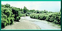
 Hole in the Rock, head water of Timpas Creek, is located north of Thatcher,
Colorado, on Highway 350.
Hole in the Rock, head water of Timpas Creek, is located north of Thatcher,
Colorado, on Highway 350.
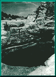
On the dry divide between the Purgatoire and Arkansas Rivers, drinking water was often scarce and bad tasting. Santa Fe Trail travelers and their livestock suffered. Susan Shelby Magoffin wrote, "This road is very badly supplied with water." They found Hole in the Rock a welcome oasis. The name for this once well known landmark comes from a hole in the bed of Timpas Creek, a water-carved storage tank, that was deep enough to retain water when the rest of the creek was dry. Its usually reliable waters made it a popular campsite on the Santa Fe Trail. In August 1845, Lieutenant James W. Abert, on an exploring expedition under John C. Fremont, found the water "pure and sweet, being entirely free from the bitter taste of the stream lower down."
 Exactly one year later, the oasis was hit hard by the needs of Stephen
Watts Kearny's Army of the West, consisting of approximately 1600 men, 1556
wagons, 20,000 horses, mules, and oxen. They were followed by more than
400 trade wagons, accompanied by Susan Magoffin. A member of the Army of
the West described Hole in the Rock as; ". . . a small, rocky branch
where a few holes or deeper cuts . . . retained a little filthy water when
all the rest was dry. Our almost famished brutes rushed into these holes
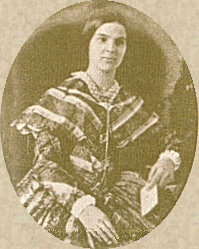
and soon stirred them to a thick mud . . . ." Susan Magoffin traveled
in relative comfort with wine and china and a servant. She was on her honeymoon,
and tended to see the world as a rosier place. Susan Shelby Magoffin waxed
poetic about the site. She wrote in her diary in August of 1846: "Hole
in the Rock, rather a place of some celebrity our camp is in tonight. The
scenery around it is quite romantic." Today, Hole in the Rock is
filled with sand, its sweet water only a memory. The railroad built a stone
dam below the hole to get water for locomotive boilers. Over time, the entire
impoundment silted in the height of the spillway. A stage station was located
near this site.
Exactly one year later, the oasis was hit hard by the needs of Stephen
Watts Kearny's Army of the West, consisting of approximately 1600 men, 1556
wagons, 20,000 horses, mules, and oxen. They were followed by more than
400 trade wagons, accompanied by Susan Magoffin. A member of the Army of
the West described Hole in the Rock as; ". . . a small, rocky branch
where a few holes or deeper cuts . . . retained a little filthy water when
all the rest was dry. Our almost famished brutes rushed into these holes
and soon stirred them to a thick mud . . . ." Susan Magoffin traveled
in relative comfort with wine and china and a servant. She was on her honeymoon,
and tended to see the world as a rosier place. Susan Shelby Magoffin waxed
poetic about the site. She wrote in her diary in August of 1846: "Hole
in the Rock, rather a place of some celebrity our camp is in tonight. The
scenery around it is quite romantic." Today, Hole in the Rock is
filled with sand, its sweet water only a memory. The railroad built a stone
dam below the hole to get water for locomotive boilers. Over time, the entire
impoundment silted in the height of the spillway. A stage station was located
near this site.
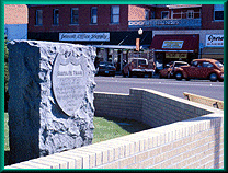 The marker was placed at La Junta's Court House Square. On Colorado
194 go west to La Junta. Turn south and cross the Arkansas River bridge.
The Santa Fe Trail crossed to the south side of the river about six miles
west of Bent's Old Fort, near present La Junta. The Marker is on the southeast
corner of La Junta's Court House Square, facing south. It is similar to
one in Las Aminas. This marker was donated in 1906 by the Daughters of the
American Revolution of the State of Colorado. The Colorado Chapter of the
Daughters of the American Revolution is at and
descriptions of activities are at
The marker was placed at La Junta's Court House Square. On Colorado
194 go west to La Junta. Turn south and cross the Arkansas River bridge.
The Santa Fe Trail crossed to the south side of the river about six miles
west of Bent's Old Fort, near present La Junta. The Marker is on the southeast
corner of La Junta's Court House Square, facing south. It is similar to
one in Las Aminas. This marker was donated in 1906 by the Daughters of the
American Revolution of the State of Colorado. The Colorado Chapter of the
Daughters of the American Revolution is at and
descriptions of activities are at
 The Arkansas River crossing was at the present-day site of La Junta,
Colorado, and may have been one of several crossings in this area. Susan
Shelby Magoffin, among others, used this crossing.
The Arkansas River crossing was at the present-day site of La Junta,
Colorado, and may have been one of several crossings in this area. Susan
Shelby Magoffin, among others, used this crossing.
In 1821, the West received word of Mexican Independence and again an enterprising group of American frontiersmen convened to discuss a trade caravan to Santa Fe. Men like Captain William Becknell knew Don Facundo Melgares, the Mexican Governor, and friendly relations assured handsome profits. William Becknell was elected by this group to lead the expedition. Deeply in debt, Becknell lost no time in organizing a pack train of mules and left September 1st 1821. From Arrow Rock they traveled west by southwest across the plains toward the Arkansas River.
 On the plains, wagons usually traveled four abreast so they could efficiently
"circle" up the wagons. The "circle" was actually a
square. The primary purpose of the squared up wagons was to create a corral
for the livestock, and incidentally for protection. Indian attacks on these
large caravans hardly ever happened and it is a myth that the wagons circled
up as the Indians attacked. As the wagons moved deeper into Indian country
and the land grew flatter, the wagons took to moving in two and often in
four parallel columns. This gave a compactness to the moving train that
discouraged attacks by the bold Kiowas and Comanches who lived south of
the Arkansas River. This formation allowed for the circle of wagons to be
formed quickly if the vehicles traveled in parallel rows. Then each column
could curve back on itself whenever the captain signaled for the train to
prepare for the campground.
On the plains, wagons usually traveled four abreast so they could efficiently
"circle" up the wagons. The "circle" was actually a
square. The primary purpose of the squared up wagons was to create a corral
for the livestock, and incidentally for protection. Indian attacks on these
large caravans hardly ever happened and it is a myth that the wagons circled
up as the Indians attacked. As the wagons moved deeper into Indian country
and the land grew flatter, the wagons took to moving in two and often in
four parallel columns. This gave a compactness to the moving train that
discouraged attacks by the bold Kiowas and Comanches who lived south of
the Arkansas River. This formation allowed for the circle of wagons to be
formed quickly if the vehicles traveled in parallel rows. Then each column
could curve back on itself whenever the captain signaled for the train to
prepare for the campground.
 After reaching the Arkansas, they followed it upstream into southeastern
Colorado to a crossing near La Junta. Here, they crossed the river and traveled
south toward Santa Fe. East of Las Vegas New Mexico they discovered a well-beaten
path taking them on a direct course to their destination. To their surprise,
the old native trail lead directly to the Arkansas River near Dodge City
Kansas. (This was the same trade trail discovered by Coronado nearly 500
years earlier while looking for the Cities of Quivera.) The discovery of
this ancient Native American trade route made wheeled trade feasible. Becknell
recognized this advantage and began to plan his next journey. The Mountain
Branch (Long Route) of the Santa Fe Trail was the 230 miles of unprotected
campsites between Fort Larned in Kansas and Fort Lyon in Colorado. It followed
the Arkansas River into Colorado before turning south.
After reaching the Arkansas, they followed it upstream into southeastern
Colorado to a crossing near La Junta. Here, they crossed the river and traveled
south toward Santa Fe. East of Las Vegas New Mexico they discovered a well-beaten
path taking them on a direct course to their destination. To their surprise,
the old native trail lead directly to the Arkansas River near Dodge City
Kansas. (This was the same trade trail discovered by Coronado nearly 500
years earlier while looking for the Cities of Quivera.) The discovery of
this ancient Native American trade route made wheeled trade feasible. Becknell
recognized this advantage and began to plan his next journey. The Mountain
Branch (Long Route) of the Santa Fe Trail was the 230 miles of unprotected
campsites between Fort Larned in Kansas and Fort Lyon in Colorado. It followed
the Arkansas River into Colorado before turning south.
 "The Wet Route" pretty much follows US 56 from the Big Bend
of the Arkansas campground at Ellinwood, Kansas, following the river to
the southwest out of Larned, Kansas to the town of Kinsley. At this point
the Wet Route stayed close to the Arkansas River all the way to Dodge City,
Kansas. At Dodge City the Wet Route continued west along the river to Bent's
Fort in Colorado. But at Dodge City, the trail changes its name to the "Mountain
Branch" US 50 west of Dodge City, Kansas to La Junta, Colorado is very
close to the route the Santa Fe Trail followed. From Bent's Fort, or from
Boggsville, the Mountain Branch did not pass through present day Las Animas,
La Junta, or Lamar. They weren't there! Present-day La Junta does sit astride
the route of the Mountain Branch. Even back then it was the juncture, the
place where the trail left the Arkansas River to travel southwest along
Timpas Creek toward the Huajatollas in the west. The route followed, generally,
what is now U.S. Highway 350 and the Santa Fe Railroad.
"The Wet Route" pretty much follows US 56 from the Big Bend
of the Arkansas campground at Ellinwood, Kansas, following the river to
the southwest out of Larned, Kansas to the town of Kinsley. At this point
the Wet Route stayed close to the Arkansas River all the way to Dodge City,
Kansas. At Dodge City the Wet Route continued west along the river to Bent's
Fort in Colorado. But at Dodge City, the trail changes its name to the "Mountain
Branch" US 50 west of Dodge City, Kansas to La Junta, Colorado is very
close to the route the Santa Fe Trail followed. From Bent's Fort, or from
Boggsville, the Mountain Branch did not pass through present day Las Animas,
La Junta, or Lamar. They weren't there! Present-day La Junta does sit astride
the route of the Mountain Branch. Even back then it was the juncture, the
place where the trail left the Arkansas River to travel southwest along
Timpas Creek toward the Huajatollas in the west. The route followed, generally,
what is now U.S. Highway 350 and the Santa Fe Railroad.
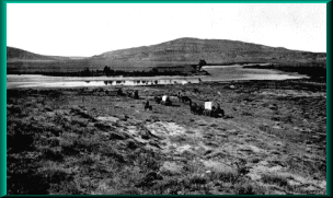
 Contact: Dr. Richard Carrillo, Phone:. Boggsville is
located on the Purgatoire River, two miles south of present day Las Animas
on Colorado Highway 101. Boggsville is open during the spring and summer
months and hosts two special events with food, music, pioneer demonstrations
and tours. The site is open daily and group tours are offered by reservation.
Annual activities at the site include "Boggsville Days", "Santa
Fe Trail Day", and a "Boggsville Christmas" party.
Contact: Dr. Richard Carrillo, Phone:. Boggsville is
located on the Purgatoire River, two miles south of present day Las Animas
on Colorado Highway 101. Boggsville is open during the spring and summer
months and hosts two special events with food, music, pioneer demonstrations
and tours. The site is open daily and group tours are offered by reservation.
Annual activities at the site include "Boggsville Days", "Santa
Fe Trail Day", and a "Boggsville Christmas" party.
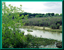
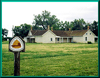
Sometime after Bent's Original Fort was destroyed in 1848, it became common for the freight trains to cross to the south side of the River to arrive at Boggsville, at the confluence of the Purgatory and Arkansas Rivers. Eventually the community of Boggsville sprang up. It was the first settlement in southeast Colorado, and officially founded in 1862. Boggsville was home to many famous pioneers such as Kit Carson. It has undergone restoration by the Boggsville Revitalization committee under the direction of Phil Peterson, Kit Carson's grandson of Swink Colorado. When restoration began, it was just a pile of rubble.
The settlement was founded by Thomas O. Boggs, his wife Rumalda Luna Bent (as stepdaughter of Charles Bent), L.A. Allen and Charles Ritc. It was built by several settlers- Thomas O. Boggs, William Bent, John W. Prowers, E. R. Sizer, Kit Carson, L. A. Allen, John Hough and P. G. Scott. To the north lived William Bent, who had moved to the area, around 1858. In 1867, Boggs was joined by John Wesley Prowers. Both men had worked for the Bent brothers and Charles St. Vrain in their trading enterprises on the Santa Fe Trail, at Bent's Old Fort and Taos (Mexican Territory). In that same year of 1867, the noted frontiersman, Kit Carson, moved to Boggsville, his last home before his death in 1868 at Ft. Lyon. The Boggs and Prowers family adopted and raised Kit Carson's ten orphaned children following his death. Hough wrote, "The families of Boggs, Carson and Ritc were one half Spanish as the wives of these men were Spanish women, The writer's wife being the only woman of Anglo-Saxon blood. The wife of Prowers being a full-blood Cheyenne Indian. Quite a mixture but we all got along very pleasantly. . . ."(Hough) During the period 1863 through 1873, until the arrival of the railroad, Boggsville became the regional center for agriculture, government, commerce and culture. Boggsville was even the site of the first school in Bent County in Las Animas.
In 1985, the site was acquired by the Pioneer Historical Society of Bent County. Restoring these structures is the major focus of the revitalization program. They also sponsor Living History activities one project being the dramatic re-creation of the Cheyenne Indian raid of 1867, for the 1994 annual meeting of the Santa Fe Trail Association. This raid was a product of unrest following the Sand Creek Massacre (November, 1864). It resulted in the death of four Indians, two soldiers and two settlers. The re-enactment was filmed and is available on VHS video from the Boggsville Store.
For more information, visit or take a virtual tour with the Boy scouts of America to Boggsville at
Site Map |
La Junta Sites |
Lamar Sites |
Trinidad Sites |
Byway Museums |
Byway Events |
Byway Links |
