 Contact the USDA Forest Service in LaJunta at for information
on access to the dinosaur tracksites. NO CAMPING OR UNAUTHORIZED MOTORIZED
VEHICLES ARE ALLOWED IN PICKET WIRE CANYONLANDS. Guided tours with the
US Forestry Service are available by appointment. Tours operate in April,
May, June, September and October. $15 for adults and $7.50 for children.
Picketwire Canyonlands is located about 25 miles south of La Junta. The
area is accessible by foot, bicycle, or horseback. Allow for a full day
hike, and be sure to bring plenty of water and food. The Canyonlands are
pristine and remote, and none of the area's rock art sites have been identified
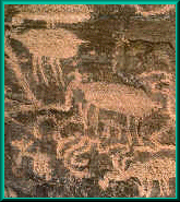
for public viewing. Look carefully and you can find petroglyphs of meandering
lines, abstract designs, and animal figures.
Contact the USDA Forest Service in LaJunta at for information
on access to the dinosaur tracksites. NO CAMPING OR UNAUTHORIZED MOTORIZED
VEHICLES ARE ALLOWED IN PICKET WIRE CANYONLANDS. Guided tours with the
US Forestry Service are available by appointment. Tours operate in April,
May, June, September and October. $15 for adults and $7.50 for children.
Picketwire Canyonlands is located about 25 miles south of La Junta. The
area is accessible by foot, bicycle, or horseback. Allow for a full day
hike, and be sure to bring plenty of water and food. The Canyonlands are
pristine and remote, and none of the area's rock art sites have been identified
for public viewing. Look carefully and you can find petroglyphs of meandering
lines, abstract designs, and animal figures.
 The primary purpose of the Grasslands is the management of 419,495 acres
or range lands and another is Wildlife Management of approximately 275 different
species of birds that use or live here. Quail, pheasant, dove, bald eagle,
golden eagle, badgers, ducks, geese and hawks, lesser prairie chickens and
longbill curlew are just a few. There are just about forty different species
of reptiles, nine amphibians, eleven fish, and lion, bear, antelope, fox,
and bobcat are among the mammals. Primary wildlife activity on the Grassland
is in habitat management improvement. Given the sparcity of trees these
creatures adapt to their habitat amazingly well. They sometimes dig in for
cover under the sandy soil to avoid falling prey to predators.
The primary purpose of the Grasslands is the management of 419,495 acres
or range lands and another is Wildlife Management of approximately 275 different
species of birds that use or live here. Quail, pheasant, dove, bald eagle,
golden eagle, badgers, ducks, geese and hawks, lesser prairie chickens and
longbill curlew are just a few. There are just about forty different species
of reptiles, nine amphibians, eleven fish, and lion, bear, antelope, fox,
and bobcat are among the mammals. Primary wildlife activity on the Grassland
is in habitat management improvement. Given the sparcity of trees these
creatures adapt to their habitat amazingly well. They sometimes dig in for
cover under the sandy soil to avoid falling prey to predators.
 The dinosaur tracks were a well-guarded secret until letters in Life
Magazine and Scientific American in 1935 reported the existence of dinosaur
track ways in the Purgatoire Valley, called Rio de las Animas Perdidas en
Purgatorio or River of Lost Souls. Despite the publicity, the site was too
remote to attract sustained scientific interest and all was forgotten until
a half-century later. The site has since been named the Picketwire Canyonlands
and came under serious scientific investigation in the 1980s. The tracksite
extends 1/4 of a mile and is considered to be the largest continuously mapped
site in North America with over 1,300 footprints in four different layers
of rock. Called the Morrison Formation (layers of strata which are 150 million
years old), this particular strata formation is famous for producing dinosaurs
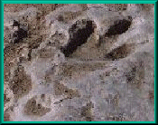
such as brontosaurus/apatosaurus, stegosaurus and allousaurus. The illustration
at left shows the type of footprints found in the shoreline strata. Therefore
the Picketwire Canyonlands site could be considered the national treasure
of dinosaur footprints!
The dinosaur tracks were a well-guarded secret until letters in Life
Magazine and Scientific American in 1935 reported the existence of dinosaur
track ways in the Purgatoire Valley, called Rio de las Animas Perdidas en
Purgatorio or River of Lost Souls. Despite the publicity, the site was too
remote to attract sustained scientific interest and all was forgotten until
a half-century later. The site has since been named the Picketwire Canyonlands
and came under serious scientific investigation in the 1980s. The tracksite
extends 1/4 of a mile and is considered to be the largest continuously mapped
site in North America with over 1,300 footprints in four different layers
of rock. Called the Morrison Formation (layers of strata which are 150 million
years old), this particular strata formation is famous for producing dinosaurs
such as brontosaurus/apatosaurus, stegosaurus and allousaurus. The illustration
at left shows the type of footprints found in the shoreline strata. Therefore
the Picketwire Canyonlands site could be considered the national treasure
of dinosaur footprints!
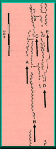 Research has uncovered that 150 million years ago two types of dinosaurs,
Allosaurus (or related theropods) and Brontosaurs left their foot prints.
Forty percent of the tracks were left by a massive four footed plant eater,
the Brontosaurs accompanied by younger Brontosaurs heading west along the
shoreline. The shores contained algae, clams, snail, crustaceans and fish.
Parallel trackways indicate that several of the smaller brontosaurs were
traveling as a group heading west along the shoreline. This evidence of
social behavior among "juvenile" brontosaurs is the first of its
kind from the Morrison Formation. The illustration at right shows the playful
pattern of the juvenile brontosaurs. The other sixty percent of the tracks
were left by the Allosaurus. They were two footed, three toed and ferocious
meat eating scavengers hunting in packs.
Research has uncovered that 150 million years ago two types of dinosaurs,
Allosaurus (or related theropods) and Brontosaurs left their foot prints.
Forty percent of the tracks were left by a massive four footed plant eater,
the Brontosaurs accompanied by younger Brontosaurs heading west along the
shoreline. The shores contained algae, clams, snail, crustaceans and fish.
Parallel trackways indicate that several of the smaller brontosaurs were
traveling as a group heading west along the shoreline. This evidence of
social behavior among "juvenile" brontosaurs is the first of its
kind from the Morrison Formation. The illustration at right shows the playful
pattern of the juvenile brontosaurs. The other sixty percent of the tracks
were left by the Allosaurus. They were two footed, three toed and ferocious
meat eating scavengers hunting in packs.
The impact of these dinosaurs is evidenced by the fossils of trampled plant stems and a collection of several dozen clams that were killed by the heavy footfalls of brontosaurs. The tracksite is the largest and most important of the 30 or more Morrison tracksites known. It has more tracks than all of the others combined. The area is rich in geological and historical resources and is a haven for wildlife. Please help reserve this area and keep it beautiful.
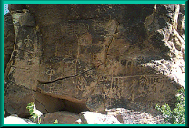
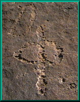
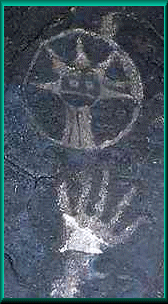
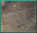 Rock Art
Rock Art images some of which may be years old have been found in Picket Wire Canyonlands. Some of these images are petroglyphs, which are are incised carvings, and some are pictographs, which are paintings on a rock surface. It is deduced by archaeologists that they were left behind by nomadic people who were hunters and gatherers. they followed migrating game and their visits were short.
 Intriguing as they may be, these lands offer an incredible amount of
history and dates from 150 million years old dinosaur tracks to late 1800
homesteads. These sites hold important clues to our past and we need your
help to preserve and protect these valuable resources. If disturbed, important
clues to our past will diminish forever. Removing, damaging, or even moving
evidence destroys a site's scientific, and often aesthetic value for future
visitors. Rock art is particularly sensitive. Please photograph but do not
touch or apply any photographic enhancing or replication materials. These
sites on public lands are protected under federal law. Please report any
acts of vandalism, defacement, or theft to the U.S. Forest Service Office
in La Junta, or Springfield
Intriguing as they may be, these lands offer an incredible amount of
history and dates from 150 million years old dinosaur tracks to late 1800
homesteads. These sites hold important clues to our past and we need your
help to preserve and protect these valuable resources. If disturbed, important
clues to our past will diminish forever. Removing, damaging, or even moving
evidence destroys a site's scientific, and often aesthetic value for future
visitors. Rock art is particularly sensitive. Please photograph but do not
touch or apply any photographic enhancing or replication materials. These
sites on public lands are protected under federal law. Please report any
acts of vandalism, defacement, or theft to the U.S. Forest Service Office
in La Junta, or Springfield
Please do not touch or disturb rock art in any way!
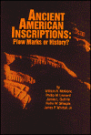 If you are interested in more information and science on the Colorado
Rocks, there is an excellent book, unbiased and also speculative, "Ancient
American Inscriptions" is available from the author, Bill McGlone.
To obtain one of these books, please contact Bill at 1214 San Juan, La Junta,
Colorado. The books are $24.95, check or money order. Don't forget to include
your mailing address.
If you are interested in more information and science on the Colorado
Rocks, there is an excellent book, unbiased and also speculative, "Ancient
American Inscriptions" is available from the author, Bill McGlone.
To obtain one of these books, please contact Bill at 1214 San Juan, La Junta,
Colorado. The books are $24.95, check or money order. Don't forget to include
your mailing address.
Most Native People's language was not written, only spoken. When two tribes with different dialects met, they often communicated with hand signs, and this practice is still sometimes used today. Martineau's ability to recognize graphic representations of these hand movements allowed him to inspire historians and archaeologists all over the West. We also recommend his book, The Rocks Begin To Speak (Library of Congress Number ).
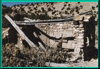 The Dolores Mission and Cemetery was built sometime between 1871
and 1889 when Mexican Pioneers first began permanent settlement in the valley.
Partial remains of the Mission and Cemetery are still visible, pictured
at left.
The Dolores Mission and Cemetery was built sometime between 1871
and 1889 when Mexican Pioneers first began permanent settlement in the valley.
Partial remains of the Mission and Cemetery are still visible, pictured
at left.
The Rourke Ranch also known as the Wineglass Ranch, was a cattle and horse ranch, founded by Eugene Rourke in 1871. Three generations of the Rourke family lived and worked on the ranch ensuring its survival over a span of a hundred years. When the ranch was sold in 1971, it was known as one of the oldest and most successful enterprises in southeast Colorado expanding from Eugine's original settlement of 40 acres to well over 52,000 acres.
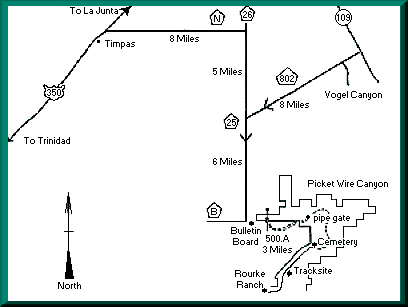 Withers Canyon is the only allowable access to the canyonlands for the
general public. Hiking, non-motorized bicycles and horseback riding are
permitted. Driving from La Junta, Colorado head south on Highway 109 for
13 miles. Turn right on County Road 802 and continue for 8 miles. Turn left
(south) on County Road 25 and continue for 6 miles. Turn left (east) at
Forest Services Road 500.A for 3/4 of a mile and go through the wire gate.
(F.S. Road 500.A is not maintained and we recommend high clearance 4WD vehicles.)
Continue following this dirt road for 2 miles until the road forks. Take
the left fork to the parking sign and park your vehicle. If you are unable
to access this road you may park your vehicle at the start of F.S. Road
500.A, at the bulletin board and start your hike there.
Withers Canyon is the only allowable access to the canyonlands for the
general public. Hiking, non-motorized bicycles and horseback riding are
permitted. Driving from La Junta, Colorado head south on Highway 109 for
13 miles. Turn right on County Road 802 and continue for 8 miles. Turn left
(south) on County Road 25 and continue for 6 miles. Turn left (east) at
Forest Services Road 500.A for 3/4 of a mile and go through the wire gate.
(F.S. Road 500.A is not maintained and we recommend high clearance 4WD vehicles.)
Continue following this dirt road for 2 miles until the road forks. Take
the left fork to the parking sign and park your vehicle. If you are unable
to access this road you may park your vehicle at the start of F.S. Road
500.A, at the bulletin board and start your hike there.
Starting your hike at the locked pipe gate you will be dropping down
in elevation about 500 feet into the canyon. Continue following the dirt
road the rest of the way through the canyon heading south/southwest. The
road is not marked except to the dinosaur tracksite. Ranching is a primary
means of livelihood in this area. Please close gates and do not disturb
livestock. Approximate Mileages: Distances: One Way & Round Trip Bulletin
Board to Pipe Gate - 3.0 miles - 6.0 miles Pipe Gate to Purgatoire River
- 1.0 miles - 2.0 miles Pipe Gate to Cemetery - 3.7 miles - 7.4 miles Pipe
Gate to Dinosaur Tracks - 5.3 miles - 10.6 miles Pipe Gate to Rourke Ranch
- 8.7 miles - 17.4 miles![]()
 Picket Wire Canyonlands became part of the Comanche National Grassland,
December 3, ,000 + acres of land was transferred from the U.S. Army
through congressional legislation to the U.S. Forrest Service (Public Law
101-150). The U.S. Forest Service is mandated by law to protect and conserve
the natural resources in Picket Wire Canyonlands. Interim guidelines have
been developed to protect and conserve precious, non-renewable resources
in the canyon and still provide appropriate public access. We encourage
you to stop by or call the Comanche National Grassland Office in La Junta,
Colorado for current weather and road information on Picket Wire Canyonlands.
They are located at 1420 E. 3rd Street, just east of Vanhooks Fruit Market
off of Highway 50 in east La Junta,. Office hours are from
8:00 am to 12:00 pm and 1:00 pm to 5:00 pm, Monday through Friday.
Picket Wire Canyonlands became part of the Comanche National Grassland,
December 3, ,000 + acres of land was transferred from the U.S. Army
through congressional legislation to the U.S. Forrest Service (Public Law
101-150). The U.S. Forest Service is mandated by law to protect and conserve
the natural resources in Picket Wire Canyonlands. Interim guidelines have
been developed to protect and conserve precious, non-renewable resources
in the canyon and still provide appropriate public access. We encourage
you to stop by or call the Comanche National Grassland Office in La Junta,
Colorado for current weather and road information on Picket Wire Canyonlands.
They are located at 1420 E. 3rd Street, just east of Vanhooks Fruit Market
off of Highway 50 in east La Junta,. Office hours are from
8:00 am to 12:00 pm and 1:00 pm to 5:00 pm, Monday through Friday.
Facilities at Picket Wire Canyonlands include:
![]() GOOD PHYSICAL CONDITION is essential to the enjoyment of your hike
as well as to your personal safety. Know your limits and the limits of the
weakest member of your group. You are only allowed in the canyonlands area
from dawn to dusk, so plan your hike carefully. Overnight camping is not
allowed in Picket Wire Canyonlands.
GOOD PHYSICAL CONDITION is essential to the enjoyment of your hike
as well as to your personal safety. Know your limits and the limits of the
weakest member of your group. You are only allowed in the canyonlands area
from dawn to dusk, so plan your hike carefully. Overnight camping is not
allowed in Picket Wire Canyonlands.
![]() SOLO HIKING CAN BE EXTREMELY RISKY and requires careful attention to
planning and to potential safety hazards. Always notify someone of your
expected route, departure and return times. In case of emergency, call the
Otero County Sheriff Office, or 911.
SOLO HIKING CAN BE EXTREMELY RISKY and requires careful attention to
planning and to potential safety hazards. Always notify someone of your
expected route, departure and return times. In case of emergency, call the
Otero County Sheriff Office, or 911.
![]() THERE IS NO DRINKABLE WATER in Picket Wire Canyonlands. Carry at least
1 gallon of water per person. Thirst will not occur until you are already
dehydrated, so drink before you are thirsty.
THERE IS NO DRINKABLE WATER in Picket Wire Canyonlands. Carry at least
1 gallon of water per person. Thirst will not occur until you are already
dehydrated, so drink before you are thirsty.
![]() BE PREPARED FOR THE HEAT, temperatures in the summer range from 90
F to 105 F. You will be walking in direct sunlight for the entire trip.
Prepare for sudden weather changes. Afternoon thunderstorms are common.
BE PREPARED FOR THE HEAT, temperatures in the summer range from 90
F to 105 F. You will be walking in direct sunlight for the entire trip.
Prepare for sudden weather changes. Afternoon thunderstorms are common.
![]() SUNSCREEN, SUNGLASSES, A HAT AND INSECT REPELLENT are highly recommended.
SUNSCREEN, SUNGLASSES, A HAT AND INSECT REPELLENT are highly recommended.
![]() WEAR PROPER ATTIRE! During summer, cloths should be loose fitting and
provide enough cover to protect your body from the sun. Wear a hat. During
spring and fall wear several layers of clothes so you can adjust to temperature
changes. A rain parka is also suggested as sudden storms can occur in the
afternoon. We recommend high-top hiking
WEAR PROPER ATTIRE! During summer, cloths should be loose fitting and
provide enough cover to protect your body from the sun. Wear a hat. During
spring and fall wear several layers of clothes so you can adjust to temperature
changes. A rain parka is also suggested as sudden storms can occur in the
afternoon. We recommend high-top hiking  boots that are well broken in before
your hike or you could be disabled with painful blisters. Carry moleskin
or molefoam and use it as soon as you feel a "hot spot," do not
wait until the blister has formed. "Tennis" shoes are not recommended
because they offer little protection from prickly pear and cholla cactus
that are abundant throughout the canyon. Socks are also important. Two pairs
can help lessen friction and heat as long as they do not unduly constrict
your feet within the boot.
boots that are well broken in before
your hike or you could be disabled with painful blisters. Carry moleskin
or molefoam and use it as soon as you feel a "hot spot," do not
wait until the blister has formed. "Tennis" shoes are not recommended
because they offer little protection from prickly pear and cholla cactus
that are abundant throughout the canyon. Socks are also important. Two pairs
can help lessen friction and heat as long as they do not unduly constrict
your feet within the boot.

![]() FLASH FLOODS CAN OCCUR WITHOUT WARNING at any time of the year. If
you find yourself in a flood situation, climb to the highest possible point
immediately.
FLASH FLOODS CAN OCCUR WITHOUT WARNING at any time of the year. If
you find yourself in a flood situation, climb to the highest possible point
immediately.
![]() A FIRST AID KIT is strongly recommended.
A FIRST AID KIT is strongly recommended.
![]() AVOID TALL GRASS! Watch where you place your hands and feet. Prairie
rattlesnakes, scorpions, tarantulas, and badgers are common. Generally,
these animals are as afraid of you as you are of them.
AVOID TALL GRASS! Watch where you place your hands and feet. Prairie
rattlesnakes, scorpions, tarantulas, and badgers are common. Generally,
these animals are as afraid of you as you are of them.
![]() PETS SHOULD BE RESTRAINED, Do not let them harass wildlife.
PETS SHOULD BE RESTRAINED, Do not let them harass wildlife.
![]()
![]() Carry out all trash, including cigarette butts.
Carry out all trash, including cigarette butts.
Site Map |
La Junta Sites |
Lamar Sites |
Trinidad Sites |
Byway Museums |
Byway Events |
Byway Links |
