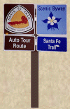
In 1987, the Santa Fe Trail was designated a National Historic Trail by the National Park Service. In the early 1990s with authorization by the Trail Systems Act, the Byway was named an Auto Tour Route under the administration of the National Park Service. They provided funds to each state for Auto Tour Route Signs which were installed on the Mountain Branch of the Santa Fe Trail by the Colorado Department of Transportation.
The National Historic Trail Auto Tour of the Santa Fe Trail is easily identified by the distinctive orange and maroon Santa Fe National Historic Trail logo pictured below. Tune in your AM Radio to 15.90 or 16.10 for the ongoing broadcast about the Mountain Branch of the Santa Fe Trail. Your radio will be your guide as you journey along the Santa Fe Trail. The auto tour is broadcast wherever you see the Santa Fe Trail triangle sign. Look for these signs on the way here and as you leave on your journey home. The Santa Fe National Historic Trail is administered by the National Park Service in partnership with other federal, state, and local agencies, non-profit organizations, and private landowners. The auto tour route has been marked along major highways that closely follow the original Santa Fe Trail route usually within two miles. Follow the Mountain Branch of the Santa Fe Trail within the comfort of your own auto through four hours of shimmering endless plains, rugged hidden canyons and pioneer history.

The traveler who wants to explore the Santa Fe Trail would do well to pick up both of the following guidebooks. Taken together, the modern explorer will have a complete guide to the Trail. Franzwa, Gregory M. "The Santa Fe Trail Revisited." St. Louis: The Patrice Press, 1989. The Santa Fe Trail Revisited provides the most complete directions to virtually every known Santa Fe Trail site, though each site is generally directed from the previous site, not from main highways. Limited maps. Generous photographs. A wonderful writing style makes this a very readable guide. Simmons, Marc. "Following the Santa Fe Trail: A Guide for Modern Travelers." Santa Fe, New Mexico: Ancient City Press, 2001 [1984].
The Santa Fe Trail was the first and most exotic of America's great pathways to the West. Spanning 900 miles between Missouri and Santa Fe, the trail was a highway of commerce. It was a thoroughfare of change and formed a link between two distant countries, permitting a rich exchange of ideas, languages, materials and food. This dusty road of the times bridged cultures and ushered in changing times. This cultural exchange survives even today. There is still a sense of adventure connected to the great prairie highway of international commerce.

The Santa Fe Trail stirs imaginations as few other historic trails can. Freight wagons no longer cross the prairies, but the Santa Fe Trail's legacy endures as buildings, historic sites, landmarks, and original wagon-wheel ruts. Come explore a unique blend of recreational and cultural activities along Colorado's Santa Fe Trail. You'll experience the wide-open expanses of the high plains, irrigated crops grown along the Arkansas River Valley, unique flat-topped mesas and majestic mountains. There are a great variety of activities to enjoy along the trail and in nearby communities. These include festivals, fiestas, fairs and rodeos throughout the year. Fishing, hunting, boating, golfing, skiing, hiking and camping are all available along the trail. Summer plays, melodramas, music, historic sites, and museums offer an opportunity to recapture the feel of America's West and learn about the enchanting and exciting Santa Fe Trail. To view a larger map of the entire Santa Fe Trail click here! Map

State highways parallel much of the trail, permitting tourists to examine remnants of the route scattered across the five trail states. Evidence exists in the form of buildings, historic sites and natural landmarks that guided travelers. Traces of the original ruts left by wagon wheels can still be found today.
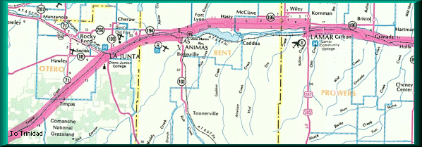
The Mountain Route of the national historic trail auto tour route is pictured above. The Santa Fe Trail Scenic and Historic Byway is 188 miles long and takes about four hours to drive. It was opened to commerce in 1821 by a merchant, William Becknell, who foresaw profits to be made in transporting American goods to Mexico. For the next 60 years, the trail was one thread in a web of international trade routes. It spans from the Kansas border to the New Mexico border and follows the original Santa Fe Trail very closely. Most of the famous American trails were one-way trails and people struggled over them once and never returned. But the Santa Fe Trail was a two-way trail of trade. While the heaviest traffic moved westward, merchants and traders sent goods in both directions from each end of the trail. Freight wagons from the east carried such items as cloth, sewing goods and hardware. They returned with silver coins, furs and mules. The types of goods which we shipped changed over the years. As trade with Santa Fe increased, wider markets were required in order to sell the goods being transported there. By 1824, some of the traders continued south to Chihuahua, Mexico. After 1865 railroads pushed westward, gradually shortening and then replacing the Mountain Branch of the Santa Fe Trail. For a printable map with the 45 top sites to visit of The Mountain Branch, click here! Map
 Heading north on Hwy. 350
From the south enter the Mountain Branch on I-25 to Trinidad and stop
into our Welcome Center complete with restrooms, smiles and bottomless cups
of coffee. Our helpful courteous volunteer staff can provide brochures and
maps on what to see and do on your journey.
From the east enter the Byway Corridor from Kansas on Highway 50 and stop
at our welcome center at Lamar. They have a friendly staff to assist you
and everything you need to begin exploring the Mountain Branch.
 Although we recommend you stop at a welcome center to familiarize yourself,
if you just want quiet solitude coming in from the North - Drive south on
I-25 from Denver to Pueblo. At Pueblo, take the highway 50 exit heading
east. Continue on Highway 50 to the intersection with Highway 350 in La
Junta. At this intersection, the Santa Fe Trail Scenic and Historic Byway
is reached. It goes east, continuing on Highway 50 to the Kansas/Colorado
state border, or southwest, continuing on Highway 350 to the New Mexico/Colorado
state border.
Although we recommend you stop at a welcome center to familiarize yourself,
if you just want quiet solitude coming in from the North - Drive south on
I-25 from Denver to Pueblo. At Pueblo, take the highway 50 exit heading
east. Continue on Highway 50 to the intersection with Highway 350 in La
Junta. At this intersection, the Santa Fe Trail Scenic and Historic Byway
is reached. It goes east, continuing on Highway 50 to the Kansas/Colorado
state border, or southwest, continuing on Highway 350 to the New Mexico/Colorado
state border.
Site Map |
La Junta Sites |
Lamar Sites |
Trinidad Sites |
Byway Museums |
Byway Events |
Byway Links |
